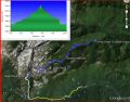
Hiking Cunningham Pass (Tunnel Creek Divide), About 11 miles roundtrip with 3900 ft elev gain, Sun 1-26-2014
The 2013 Winter has been mild so far. It appeared that the Olympics mountains received less than 25% snow compared to the previous years. Weather forecast for the week has been cloudy but the Sunday appeared to be sunny. Just one week ago, it was similar weather that the Saturday was all blue sky. After helping my brother install the floors on Saturday, I wanted to hike. I have been helping my brother install the floors over three weekends (2 days, 1 day, and 1 day).
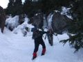
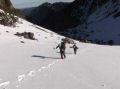
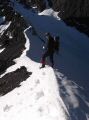
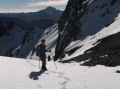
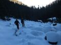
I suggested Paul and Les hiking the Cunningham Pass that I hiked back in August 2013. Back then, actually, I did not get to the Pass. It were so foggy that we could not see the surroundings. For this week hike, we were all prepared with snowshoes, foot tractions (micro spikes), and ice axe. At the trailhead, we decided not to take the snowshoes. Well, the need for the snowshoes was marginal. It would have been nice at some places but would have taken us more time to put them on remove them back and forth. The upper basin above 5300 ft elev had only 1 ft of snow. It is usually over 4 ft during this time of year. We used Les' 4x4 Tacoma. There were some patches of snow and ice on the access road. A 4x4 car was a must.
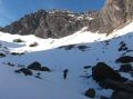
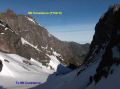
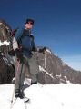
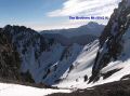
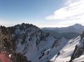
It turned out it was an incredible day in the Buckhorn Wilderness, Olympics National Forest. It was all blue skies with 30s-50s. It was balmy that felt like a summer weather at 6300 ft elev in the middle of the Winter season. We reached to the Cunningham Pass where the mighty Mt Constance (7743 ft) could be observed up-close. Took us 4.5 hours to the Pass, and my quads were burning. I was the slowest to get up there. Mt Constance (the tallest Olympics mountain you may see from the Seattle) was stunningly beautiful. The 2nd half of the route was sort of way trails (not maintained trail). Each stride needed to be taken with caution. Time spent was 0820-1630.
Here was the direction I documented during the Aug 2013 hike. When we were going up, I went too much East trying to stay away from the patches of snow that ended up going away from the creek. However, we came down on the right estimated route.
Short description of its estimated route (elev and miles) that was copied from August 2013 trip:
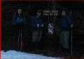
1. Tunnel Creek Trailhead (2480 ft elev). Established
trail. 2.7 miles to Stock Crossing.
2. Right after Stock Crossing (3700 ft elv) before the
log bridge, follow an obvious way trial.
Then, way trail started to fade. Do not follow the pink flags too long.
Follow 2-3 notch marks (blazes) on the trees.
Stay close to the creek (should be audible at all time). Navigate through down trees to the North East if necessary
but come West to stay close to the
creek.
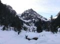
3. Arrives to Rocksides (4400 ft elev) around 3.7
miles. Over the rockslides, stay
left. At some points, there are some
steep sections but thin forest with many down big trees. Zig and zags by following some notch marks. Stay close and right of the creek Near the mid Basin at 4950 ft, see some huge
"Cut" trees that lead to the small meadow and mid basin.
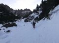
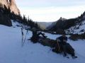
4. Arrives to Mid
Basin (4920 ft elev) at 4.2 miles. An
open area but a huge mass of fallen trees and huge boulders. Route to Upper
Basin can be tricky. Need to go around
to the left side just below a rugged sharp peak.
5. Upper Basin (5360 ft elev). 4.6 miles. Due to thick fog, we could not see anything
but I imagine that one should see the Pass to the North above steep shale.
6. The Cunningham Pass is on the North side of the Basin
at about 6300 ft elev. 5.5 miles.
Click Here to the Link to Youtube Video:
|
|
|
|
|
|
|
|
|
|
|
|
|
|
|
|
|
|