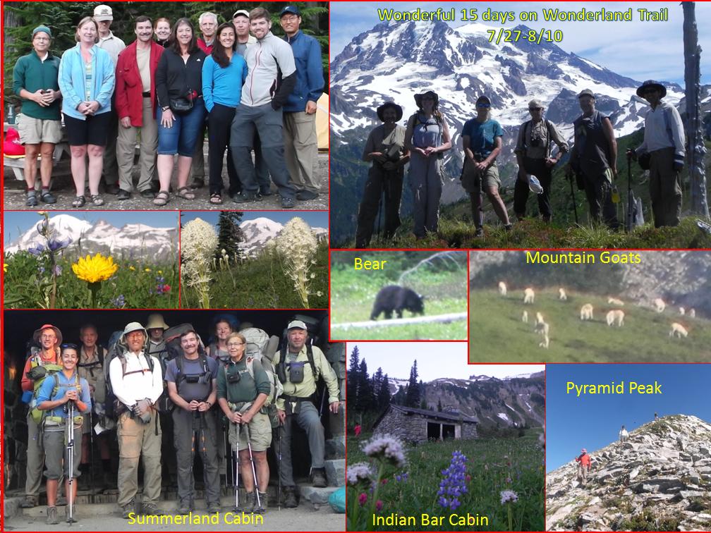
Wonderful 15 days on Wonderland Trail (Backpacking
around Mt Rainier)
(about 95 miles +
optional 56 miles of side trips) - (7/27 - 8/10, Summer 2014)
Youtube Video Links:
Video 1 of 4 (7/27 - 7/31). Spent 12-14 hours to make.
Video 2 of 4 (8/1 - 8/4). Spent 10-12 hours to make.
Video 3 of 4 (8/5 - 8/7). Spent 6-8 hours to make.
Video 4 of 4 (8/8 - 8/10). Spent less than 4 hours to make.
It's been just over 4 years since I have been hiking,
backpacking, climbing, mountain biking, and kayaking. Since I'm not retired and need to spend
some time with my family at home, my passion has been in day hikes mostly in
the weekend. Also, in
each year, I have been able to
squeeze in several multi-days backpacking , climbing, cross country skiing, and
sea kayaking trips. Surprisingly, I have not hiked
one single trail in Mt Rainier area during those years.
It's mostly due to it's driving distances and also lack of my outdoor
club activities in the Mt Rainier area since we are closer to the
Olympics. For the Mt Rainier
area, I snowshoed Camp Muir 3 times that
included climbing the Mt Rainier via Camp Muir once. And I cross country skied and snowshoed all
4 Huts & Yurt at the Mount Tahoma Trail Association (MTTA) Trails where
it's located near the Ashford area which is about 12 miles west of the Longmire
Ranger Station and another 12 miles to the Paradise MRNP (Mt Rainier National
Park) visitor center.
For backpacking the Wonderland trail, camping reservation is recommended in advance. About 70% of the MRNP wilderness permits can be reserved via fax, letter, or in-person starting on 15 March each year while the remaining 30 percent are issued on a first-come, first-served basis. The permits are issued in mid April. It's quite difficult to get the permits as its trail is very popular and allow to camp only at the designated camp sites. A few PWC (Peninsular Wilderness Club) members applied the camping permits and one person received a group permit (6 - 12 backpackers). Although it was a group trip, we backpacked on our own pace. Since we were on a well maintained and marked trail, it's quite difficult to get lost. So, I backpacked solo more than half of the time at my own pace. I was not moving faster than I would like to and my physical condition did not allow to do more side trips. Bill, a marathorn runner, was very strong at his age, and was my inspiration for strength. We did a couple of side trips together.
Since it's a 15 days trip and not an easy trip, the billets did not fill up quickly. I was hesitant because I was not sure if I could take 2 continuous weeks off from my work. For over 23 years, I have been working right after graduating from college, I don't remember if I had ever took 2 weeks straight vacations. I think that this trip was the first. The schedule turned out to be just right for me with my work schedule. That meant, I had to keep low profile staying most of the weekends at home, and make my family happy. I signed up for the trip on 4 June during Monthly PWC meeting. Since then, to keep myself in shape, I was able to do a few long or tough dayhikes, mountain bike riding, and some sea-kayak paddling on Wed, Fri, Sat, or Sun. I wanted to practicee an overnighter backpacking but did not happen.
It was great to knock off the Wonderland Trail at once and another 56 miles of side trips in 15 days ! The weather was simply amazing. Only one day was cloudy. One day we had a thunderstorm and drizzled about 2 minutes. We could not ask for a better weather for 15 days in Washington State. The bugs were moderate, except for, at the Devel's Camp just below the Indian Henry's Ranger Patrol Station. During the entire trip, temperatures were mostly in mid 50s-mid 70s on the trail. I actually never slept in the sleeping bag but used the sleeping bag as a blanket for the whole trip !
Its trail was truly "Wonderland Trail" as referred in its name sake. The huge Mt Rainer was pretty much visible every day. In the mean time, I never felt that I was lonely and never felt that I was in a deep wilderness. I felt like I was on a local trail that was frequented by the locals at all time. I encountered numerous dayhikers and backpackers, a couple of trail runners, a bunch of visitors, etc. A strong day hiker could probably day hike most of the trail up to 30 miles at a time. Looked like the popular trail runners routes were Longmire, Mowich Lake, White river, and Longmire, which compete the Wonderland Trail Loop in 3 days !
I probably won't backpack the Wonderland Trail as a solo, but willing to sponsor some trips for the others to enjoy in the future. Its trail is not about solitude in the wilderness but to get together, to experience backpacking, to socialize, and to have fun. It's a wonderful trail getting together with family, siblings, outdoor clubs, friends, etc. Water supply is abundant, trail is well maintained with markings, and there was almost no danger from wild animals. Be aware of the bugs during its peak season though. They can be very unpleasant. Backpacking itinerary can be moderate by making less than 6-8 miles, but can add many optional side trips for the strong backpackers. Basically, there are tons of side trips that one can make in high country (above 4000-5000 ft elev). Strongly recommend to do some research such as looking for a Benchmark (that usually has some trail), get the GPS coordiantes, and use of a GPS unit.
Day 1 (Sun,
7/27). Drove to Mowich Lake
(4930 ft elev). 1130 - 1530. Bill, Robert, Suzy, Linda,
and I carpooled. 11 of us gathered at
Mowich Lake (4950 ft elev) and camped overnight. 3 of them did the first leg and hiked out to
Sunrise on 5th day. Fred joined us at
6th day at Summerland. Thanks to Dave's
(Trip Leader) party who took care of the Food Caches at White River (Food Cache
#1) and Longmire (Food Cache #2) Ranger Stations.
a. Optional Side Trip (After Camp): Eunice Lake and Tolmie Peak Look out
(1400-1900). About 6.5 miles with 1200
ft elev gain/loss.
Click Here for more detail and pictures:
Day 2 (Mon, 7/28).
Mowich Lake to Carbon River (3200 ft elev). Backpacked 9.3 miles with 2100 ft gain
and 1750 ft loss.
a. En route:
Visited Spray Falls. About 0.30 miles with 135 ft gain/loss
b. Optional side Trips (En Route): Obstruction
Point/Observation Rock. 5 miles
round trip with 2150 ft gain/loss
Click Here for more detail and pictures:
Day 3 (Tue, 7/29). Carbon River to Mystic Lake (5600ft elev). Backpacked 4.90 miles with 2970 ft gain/2390 ft loss.
a. Optional Side Trip (After Camp): Carbon Glacier /
Mineral Mountain. 3.60 miles with 1450
ft gain/loss
Click Here for more detail and pictures:
Day 4 (Wed, 7/30).
2nd night at Mystic lake.
a. Optional Side Trip: Old
Desolate Day Hike. 8 miles with 3300 ft elev gain/loss.
Click Here for more detail and pictures:
Day 5 (Thur, 7/31).
Mystic Lake to Glacier Basin (5980 ft elev). Backpacked 12 miles with 4100 ft gain and
3610 ft loss
a. Optional Side Trip (En Route): Skyscraper Mt.
1 miles with 600 ft gain/loss.
b. Optional Side Trip (En Route): Fremont Lookout.
2.6 miles with 500 ft gain/loss.
c. Optional Side Trip (After Camp): Visit Inter Glacier
(route to Camp Shurman). 1.8 1180 1180
Click Here for more detail and pictures:
Day 6 (Fri, 8/1).
Glacier Basin to Summerland (5980 ft elev). Backpacked
11 miles with 2810 ft gain and 2830 ft loss.
a. Picked up Food Cache # 1 at White River (En Route)
Click Here for more detail and pictures:
Day 7 (Sat, 8/2). 2nd night at Summerland. Goat Island Mountain Day Hike. 7 miles with 2700 ft gain/loss
Click Here for more detail and pictures:Day 8 (Sun, 8/3).
Summerland to Indian Bar (5064 ft elev). Backpacked 4.50 miles with 1420 ft gain /
2320 ft loss.
a. Sarvant
Glaciers / Cowlitz Chimneys Day Hike (En Route). 3 miles with 900 ft gain/loss.
Day 9 (Mon, 8/04). Indian Bar to Maple Creek (2750 ft elev). Backpacked 11 miles with 1770 ft gain and 4100 ft loss. Visited Box Canyon.
Click Here for more detail and pictures:
Day 10 (Tue, 8/05).
Maple Creek to Paradise River (3725 ft elev). Backpacked
8 miles with 2550 ft gain/ 1560 ft loss.
a. Optional Side Trip (En Route): Bench Lake / Snow Lake Day Hike. 3
miles with 600 ft gain/loss
Click Here for more detail and pictures:
Day 11 (Wed,
8/6). Paradise River to Devil's
Dream (4839 ft elev). Backpacked 10.5 miles with 2450 ft elev gain/ 1100 ft
loss.
a. Pick Up Food Cache # 2 at Longmire (en Route)
Click Here for more detail and pictures:
Day 12 (Thur, 8/7).
Devil's Dream to South Puyallup River (4004 ft elev). Backpacked
7 miles with 2100 ft gain/ 2920 ft losss.
a. Mirror Lakes
and Pyramid Peak Day Hike (En Route). 5
miles with 1700 ft gain/loss
Click Here for more detail and pictures:
Day 13 (Fri, 8/8).
South Puyallup River to North Puyallup River (3716 ft elev). Backpacked
7 with 2250 ft gain/ 2510 ft loss.
a. "ANDREW" Benchmark Day Hike (En Route). 2.5
miles with 800 ft gain/loss
Click Here for more detail and pictures:
Day 14 (Sat, 8/9). North Puyallup River to Golden Lakes
(4960 ft elev). Backpacked 6 miles with
2050 ft gain/ 800 ft loss.
a. "SUNSET" Benchmark / Sunset Park Day Hike
(After Camp). 7 miles with 1000 ft gain/loss
Click Here for more detail and pictures:
Day 15 (Sun, 8/10). Golden Lakes to Mowich Lake (4930 ft elev). Backpacked 10 miles with 2750 ft gain/ 2800 ft loss.